
 |
| Roxboro |
Collège Gérald-Godin
 |
| Collège Gérald-Godin in 1947. Notice the small trees in a line in front. |
 |
Collège Gérald-Godin in 2012. Notice the tall trees in front of the Collège |
Big Photo-gallery of photos of Montreal from the past HERE
In these old photos of ( the island of Montreal) the west island there are no power lines and no highways.
The official website is
http://donnees.ville.montreal.qc.ca/dataset/vues-aeriennes-archives/resource/b31b6750-638c-4368-840c-752fb04095b0?inner_span=True
If you want to see Aerial Photos of Montreal in the year 1947-49 , you will first need a Guide map of the island Montreal with numbers on it.
2574 x 1200 1.76 MB (link)
 |
| Guide map |
Next, if you can find "vues_aeriennes_archives.csv" 600 KB open the file in the program "notepad.exe". It will be a long list of HTML addresses.
You do not need this file, using logic you can figure out what numbers to put in to find the location you are interested in.
In the list, the first photo is named
http://archivesdemontreal.com/greffe/vues-aeriennes-archives/jpeg/VM97-3_7P1-01.jpg
The last photo is named
http://archivesdemontreal.com/greffe/vues-aeriennes-archives/jpeg/VM97-3_7P47-89.jpg
____________________________________
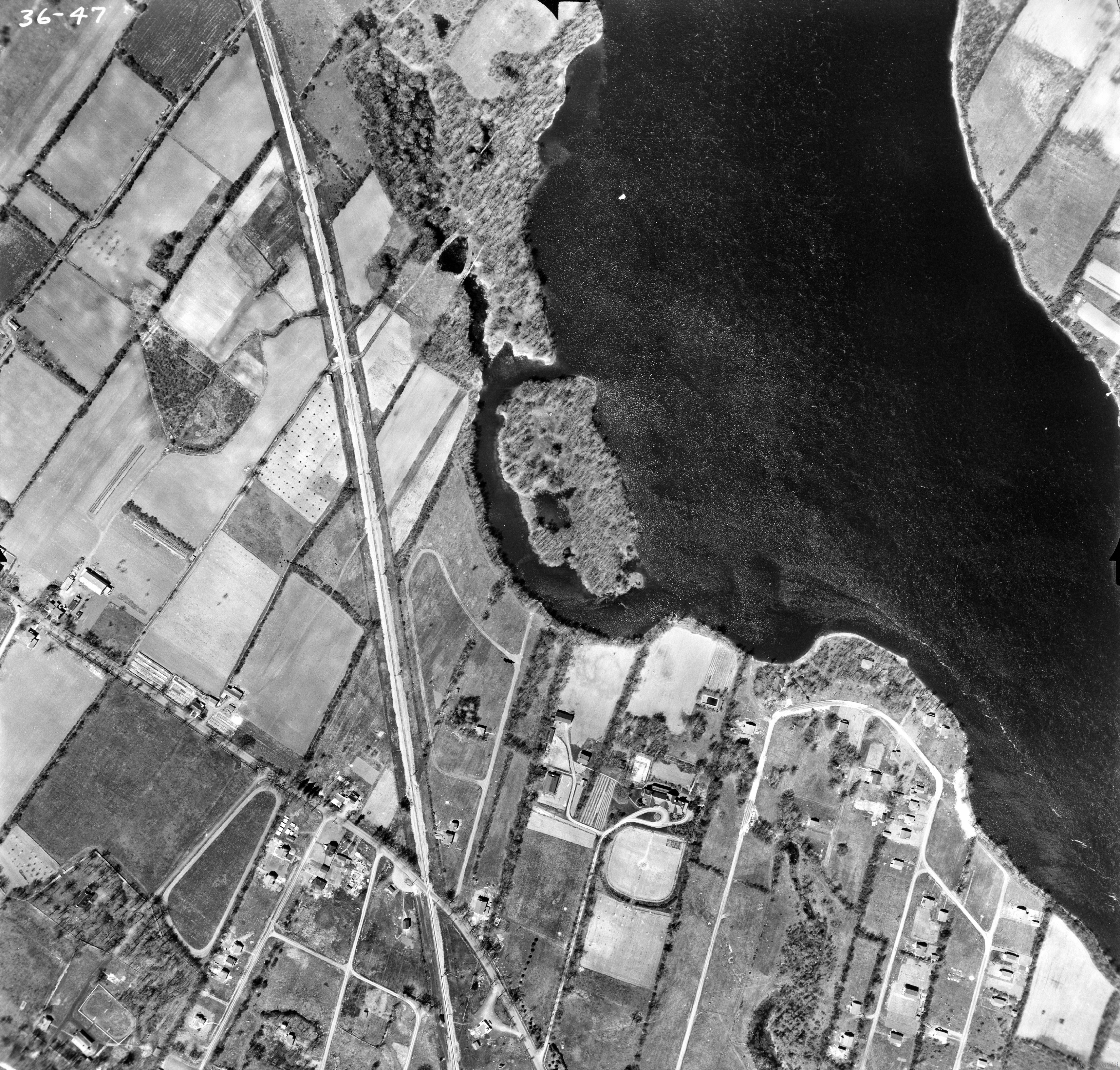
VM97-3_7P36-47 is a Aerial photo of Roxboro.
http://archivesdemontreal.com/greffe/vues-aeriennes-archives/jpeg/VM97-3_7P36-47.jpg is the photo image.
Only the last 5 digits of the HTML list matter.
The 36 in the Roxboro example is linked to the Y axis of the Guide map.
The 47 in the Roxboro example is linked to the X axis of the Guide map.

_______________________
Lelande/Lalande (Lot 55)
 |
| Lalande house 1968 Photo from the North Shore News |
 |
| Modern map |
 |
| 1879 map of Hopkins Henry Whitmer |
 |
| 1947 Aerial Photo of Lalande |
 |
| Lalande farm 1947 circled in red |
 |
| Lalande farm 1947 (close) North east corner of Gouin Blvd and Source Road |
 |
| 1947 Lalande house |
 |
| Two windows in roof circled (1968) |
 |
| Two windows in roof circled (1947) |
The ancient structure on the north east corner of Gouin Blvd and Source Road is over 200 years old and is the property of Dr. Eugene Lalande of Temiskaming, brother of Pierrefonds' Alderman Eddie Lalande.
The site is appropriately zoned for the construction of a drive-in restaurant and work is expected to get underway as soon as the demolition is completed. The restaurant is expected to cost in the neighbourhood of $60,000 including paving of the lot and various fittings. The land has been taken under a 20 year lease.
Standing on the site looking on somewhat sadly as four generations of Lalande family history fell under the wrecker's crowbars and hammers, Alderman Lalande said the house was so old he was not even sure himself when it had originally been built, nor could he recall the christian names of the original owners. He said that to the best of his knowledge, the original easternmost portion was well over 200 years old. The westernmost smaller portion had been erected aproximately 80 years ago when the Lalande family began to expand.
"In those days the people often lived in what you would call the cellar of the house which is why there's a wood floor in the basement and wooden walls," Mr Lalande explained.
He said it was painful to see the old family homestead, where he and so many of the other Lalandes had been born, falling to the wreckers but added that his brother had little other alternative.
"The house has been empty for the past four years since my mother died. During that time we've offered it to many associations to make use of for meetings but no one seems to be very interested in making use of the building or saving it because of the historical value. In the meantime, taxes continue to pile up so my brother felt there was really nothing else he could do but lease the land to the restaurant people."] North Shore News wrote.

_____________________________
Meloche House (Lot 265)

Many parcels of land on the "West Island" belonged to the Meloche family.
 |
| 1879 map of Hopkins Henry Whitmer |
 |
| North Shore News Oct 11 1973 |


______________________________
Bridge to Ile Bizard
 |
| 1947 photo of the bridge to Ile Bizard |
 |
| 2012 photo of the bridge to Ile Bizard.(The new bridge was built a bit east of the original) |
_______________________
Other historic houses that I know of
 |
| 18445 Gouin Blvd |
 |
| 17865 Gouin Blvd Now Gone. New buildings on the land |
 |
| Theoret house. Lot 261 |
 |
| Kirkland Quebec |
 |
| 14883 Blvd Gouin |
 |
| Rue Meighen . Roxboro. East of 5th Ave North |
 |
| 15510 Gouin Blvd (approx) Ste Genevieve |
 |
| 16017 Gouin Blvd (approx) Ste Genevieve |
QUEBEC ANGLOPHONE HERITAGE NETWORK-HeritageLine
http://montrealmosaic.com/links
____________________
I had some unpleasant negative stuff here , but I deleted it.
The human growth rate is dropping. We just have to make what we have sustainable using Renewable resources.

Human population is decreasing in developed countries where women have access and/or the choice of having children. In fact the level is below replacement level.
______________________________
:Note i found another house that may have been historical. I have to check 1947 photos https://www.google.ca/maps/@45.492935,-73.853834,3a,90y,319.05h,87.73t/data=!3m4!1e1!3m2!1s9DbX3-BJFezMRs6NYP8VAw!2e0
Top north of St Jean Blvd, there is a ?10 story Condo there now, In the 1960-70s there used to be a "greendale" boat club at the top of St Jean.
*Note 2
To manipulate 1947 images with IrFanView, the image must have material added to all four sides beforehand, as when IrfanView spins it, it loses material.
"Effects browser" window must be opened to find the precise angle of rotation. Otherwise a default spin of 45 will be applied.
Note 3
Photos now appear to be fairly square, where in the past I believed them to be rectangular.
Scale in the photos is still a problem. 400= 1 or 400 feet equals one inch, is fine but there is no one inch scale on the photos to start off with. The photos can be any size.
Feb 1 , 2016
My working plan now is to turn google or bing maps capture to the same angle as the black and white photos, then take a screen cap of the black and white photo ( that is open in a browser, where the photo size is variable)
Feb 5, 2016 Looks like a 30 degree change after turning 90 degrees
Ile Menard


No comments:
Post a Comment